

You must log in or register to comment.
The kinda shit I do in cities skylines when I get bored
Idk why, but this is oddly satisfying to me.

Then there’s Pittsburgh. It’s like Boston but when you take a wrong turn you end up on the wrong side of a mighty river or two.
actually tho, flowing windy streets and roads are so much better.
- more interesting
- less of a drag track
- not depressing stroadie strips
- keeps people on main roads rather than just trying to cut through residential streets
- naturally manages driver attention
I wish, just check Atlanta - winding stroads as far as the eye can see
Yes to all, especially the driver attention one.
I have two options when driving to work. One is shorter and takes straight level roads through the newest part of town.
The other way is slightly longer but it’s a twisty hilly road through the countryside.
I take the longer route every single day unless it is actively snowing or something. And now that hybrid WFH is a common thing, I don’t often drive in the snow.
I mean, you can organise grids to be more or less stroady, and if you have too much of this going - like you have a medieval street plan - you can get the opposite thing where cars are forced through areas only suited to pedestrians, and everyone has to flatten themselves against building walls to make room.
but the point is that by not organizing it into a grid at the local level, drivers aren’t going to cut through a low speed local street, keeping those streets less polluted and safer.
I mean, there’s more options than just tree or grid, and if it’s not strictly a tree the fastest route from A to B could be something small again. And of course trees have their own issues, like what happens if you need to get from one leaf to another that’s nearby, but only as the crow flies.
That example about having to move aside for a car going through a narrow European street was something I’ve actually experienced. Maybe it’s just my Canadian brain but it felt unsafe.
Less intersections where cars can crash into pedestrians or other vehicles
Boston looks much easier to navigate though. Much clearer road hierarchy, meaning better flowing traffic, and less traffic near houses and shops.
Disclaimer: above statement is based on the image posted here, not on knowledge on the actual situation.
Where I’m from cities like Boston are the norm. When I was in a grid city for the first time, I immediately got lost on the roads because everything just looks the same.
On the other hand, Americans seem to have a more intuitive sense of the cardinal directions than Europeans do from my experience. Which makes sense if you’re used to roads aligned with them.
I am familiar with Boston, and the 2 times I have driven in nyc it was SIGNIFICANTLY easier to navigate than Boston lol. NYC was at least partially thought out, Boston is what you get when your road planner is a 3 year old toddler who threw a hand full of spaghetti on a map and said theres your streets LOL. Possibly the most annoying city I have had the misfortune of navigating lol.
Yeah, Boston is chaos and it is super easy to get lost. And you’ll have two roads converging and splitting and you gotta just hope you’re in the right place!
Welcome to everywhere else in the world that’s not a fucking grid lol.
This isnt a computer where traces are made in 90 and 45° angles.There weren’t computers when NYC’s grid was laid out either.
And the ancient Romans, and Indus valley people another couple millennia earlier were both fond of grid plans.
They’re considered passe, but there’s real advantage in terms of easy scalability and adaptability to changing land uses.
Well, there were. But back then computers had hair and nails.
Mmm, hot computers. Giggity.
Lol get fucking rotated

They probably did it so they could squeeze one more house in when building the track.
How about a grid system that changes direction at every single avenue?

Speaking as someone who has been living in towns with rivers for most of my life:
This is the way.
My experience clearly says that you will loose orientation and get confused the moment you go to a district that is not alligned with the riverbank.
Looks like everyone started a new road perpendicular to the shore line, and the mess occurred when the roads got long enough to meet.
No they’re were designed that way. The names remain the same no matter how many times they turn. The street i live on starts off going west, then south, then south west and back to west again on the other side of town.
Bingo. Allow me to introduce you to the colonial French seigneurial system.
There has to be some interesting history here.
A few other examples have been posted, but this is easily the wildest. It’s not even the same aspect ratio of grid, or at a normal angle to the rest, or over a very significant area. (And they’ve still managed to tie it in reasonably well)
I think that area was built when nothing else was there, without the developer thinking too hard about its orientation.
As time went on, new development started nearby, oriented to a different geographic element, like a shoreline, or a river, etc. eventually that development met the old development, and they were lined up differently, and the municipality stuck with the new grid system orientation and just built around the old one.
Yeah, someone deciding to clear out an area and develop it in a completely different way is possible, I guess, but seems a lot less likely. Maybe there’s a bit of both - something large like horse stables or a hospital was there, then it was replaced with a new self-contained development, and then they built out into the margin around it later on yet.
In any case, somebody had a big urban planning idea of some kind, but it hasn’t really continued to make sense as things changed. The angle could be because one grid is aligned true north, and the other magnetic north.
Could also have been a remnant of say a grove or something and was simply developed later on. There’s a couple of these type of things near me caused by my great grandfather being weird, where the streets are all fucked in their width because they’re built on the old trails and roads. Sometimes the roads are only wide enough for a single car other times you could fit four next to each other with room to spare, also all the blocks are weirdly sized because they were built at slightly different times so are all oriented towards different cardinal directions.
To me what’s wild about it is that it’s completely filled with houses, and the houses seem to all respect the orientation of the nearest street.
You’d think that they’d say “Ok, well in this section we have these two roads coming at a narrow angle, let’s just make this a park”, or something to make the places where the two grids join a little less ugly.

Is this the most efficient way to store 17 houses?
So much more room for delicious maple syrup.
Waffle.
It’s called being optimal sweaty.

This is what I immediately thought of. I actually thought it was an AI construction, as a joke.
Sweety.
Optional sweaty is the perfect amount of perspiration to have upon one’s person.
The misuse of the word is intentional and part of the joke. An artifact from reddit.
*Optimal
Optional sweater is when you choose to perspire
*sweaty
Opinionated sweater is when somebody offers to refund the sweater they gave you as a gift
*sweaty
Optional Sweater is when you have the exact correct sweater for the occasion
Optimal. Optical sweaty is the choice of whether or not one would like to be perspiring.
Optional. Optical sweaty is when you are so sad that your eyes start to vacuum tears.
Optimus. Optical sweaty is when you are more than meets the eye.
That’s having a thin layer of liquid perspiration that’s constantly boiling off and evaporating
I kinda like it. It’s just neat enough.
A lot of old city plats follow the exact pattern of that square, so I’d be curious what the sequence of development was.
It’s tough to look at, but I bet it’s amazing for traffic calming.
Came here to say the same. This design (or accident) forces north/south traffic to use the arterials on either side of the neighbourhood instead of going through the neighbourhood.
Reminds me of this place:

(I remember just walking to school and it felt weird walking on a “slanted” street lol)
Old train tracks?
Sort of… its a subway… built over ground… right over the street… (colored lines are the subway)


Omg this is so nostalgic… just looking at the streetviews…
This was basically what “my world” looked like when my family first immigrated to the US…
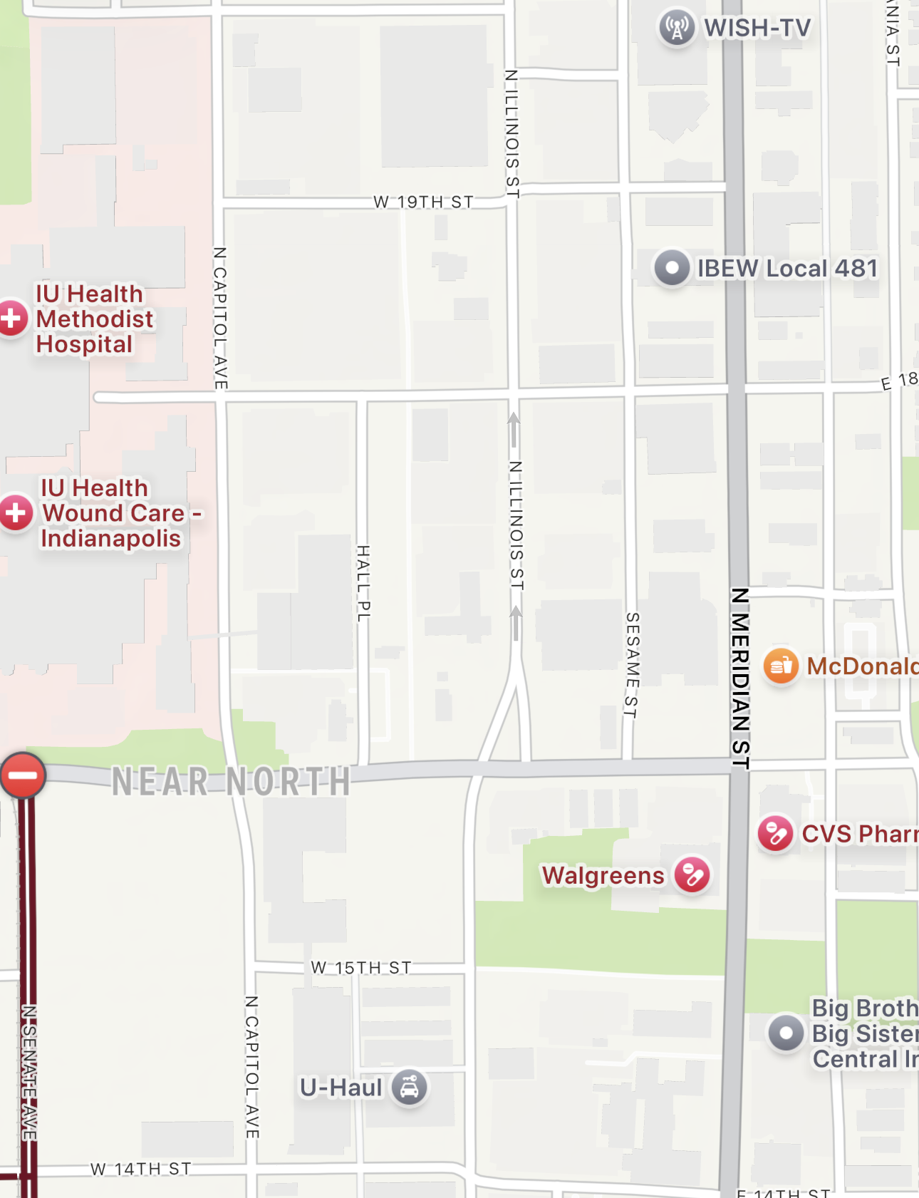
Indianapolis built the central mile square of streets aligned with magnetic north, but then the rest of downtown aligned with true north. It’s almost aligned, which causes problems at that border.
I’ve lived here for years and never realized that’s why everything in the center looked slightly off center. Thanks!
I lived downtown for a couple of years and drove north on Illinois street to get to work. This swerve as it crossed 16th street and the corresponding confusion to drivers just about killed me a few times.


